The heating market is undergoing a transformation. Technological innovations, new building regulations and targeted subsidies are accelerating the development and use of renewable technologies in the heating sector and the gradual replacement of fossil-fuel systems. Little attention has been paid to date to the issue of energy in spatial planning processes. Planners, investors and political decision-makers lack structured information on renewable heat sources available locally and realizable technological systems at a site. Another key task is to coordinate the deployment of the various technologies to avoid parallel infrastructures (no other technologies in heating network areas) and mutual interference (e.g. overexploiting areas of geothermal potential). The heating transition will only succeed if each and every location is using the most suitable technology. Integrating energy-related aspects into the spatial planning processes is a key for the coordination of energy transition.
Spatial energy planning: a real game-changer
This is where the SEP – Spatial Energy Planning project comes in, a partnership between the federal states of Vienna, Styria and Salzburg being implemented as part of the “Green Energy Lab” innovation laboratory.1 Led by the Salzburg Institute for Regional Planning and Housing (SIR), partners from the various states (state governments, state capitals and individual flagship municipalities) are working together with Austrian research institutions2 to lay all the necessary foundations for introducing spatial energy planning. The aim is to be in a position to harness the potential harboured by all forms of renewable energy and make the best possible use of the available resources and infrastructure. To this end, an innovative online information system has been developed that enables spatial and energy-related data and information to be made available and linked together. The first phase of the project focused on the heating sector. Spatial energy planning has the potential to become a real game-changer in this field and provide a substantial boost to the integration of sustainable heating technologies and the development of new market and business models.
An innovative planning tool
The central tool is the ENERGIEatlas, a GIS-based online application that supplies layers of cartographic information on energy requirements, energy supply infrastructure and potential for renewable energy supplies. Linking many different sources of basic data (up to a three-digit number in each federal state) with robust scientific models and methods creates an innovative, comprehensive basis for planning. This can map individual buildings in its smallest resolution as well as other entities such as sites, municipalities, regions and states in a consistent manner. Building on this, an application was integrated that facilitates automated queries and analyses for specific administrative processes. This will provide effective support to site development work, spatial planning and the development and monitoring of energy strategies in the future. With the completion of the first phase of the project, all features for the heating sector are set to be available in June 2021.
Near-surface geothermal energy
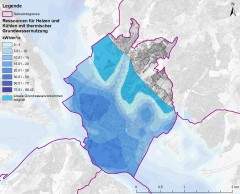
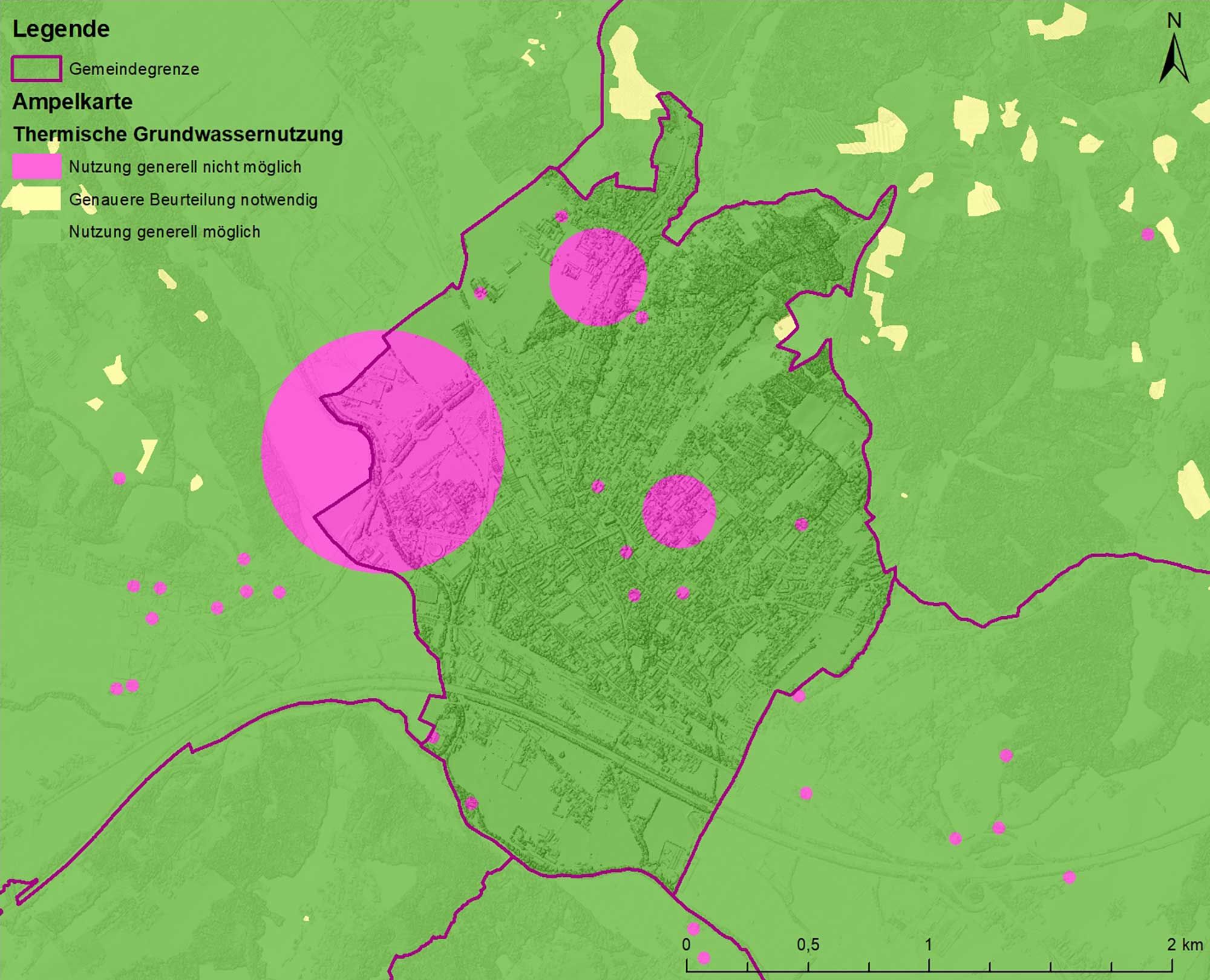
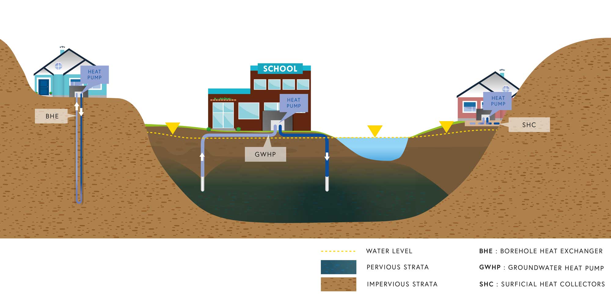
Einen Spatial energy planning can deliver significant added value for making greater use of the potential afforded by geothermal energy in Austria. The ENERGIEatlas maps the various options for harnessing near-surface geothermal energy using three kinds of systems: borehole heat exchangers, groundwater heat pumps and surficial heat exchangers. This sector falls within the remit of the Geological Survey of Austria (GBA), which boasts an extensive database and significant specialist expertise gained from numerous projects both within the country and further afield. The GBA is using newly developed methods that allow energy resources and limitations to near-surface geothermal energy to be estimated accurately right down to specific plots of land. Content is presented in the form of maps and, via a query function, as a report, thus providing a compact summary of all relevant information on each individual location. Potential restrictions on the use of near-surface geothermal energy are displayed visually using traffic-light maps (separated into borehole heat exchangers, groundwater heat pumps and surficial heat exchangers) and in the location query function. The SEP tools enable the functionality for geothermal energy to be utilised in the planning process.
An upgradable system
As part of the SEP project, a scalable system was created that planners, investors, political decision-makers and citizens will be able to use in future and that can be transferred to other federal states and regions. Comprehensive information on the potential for near-surface geothermal energy is already available for Vienna and the state of Salzburg. Digitalising the underlying information has opened up a highly promising pathway over the past few years that offers huge potential for further development. The example of geothermal energy shows how all manner of different areas can tie in with it. In the project itself, meanwhile, the second phase will begin from summer 2021 onwards. In the next three years the power and mobility sectors will be integrated and cities from other federal states will participate as “followers”.
waermeplanung.at
1 SEP is a project under the umbrella of the “Green Energy Lab” innovation laboratory, a research initiative for sustainable energy solutions and part of the Austrian “Flagship Region Energy” innovation campaign.” www.greenenergylab.at
2 PROJEKT PARTNERS: SIR – Salzburg Institute for Regional Planning and Housing (project management), Energieagentur Steiermark GmbH, Grazer Energieagentur GmbH, UIV Urban Innovation Vienna GmbH, Vienna University of Technology – Energy Economic Group, Graz University of Technology – Institute of Thermal Engineering, AEE INTEC, e7 Energie Markt Analyse GmbH, RSA Research Studios Austria iSpace, Vienna City Council, Government of the State of Salzburg, Building department of the City of Salzburg, Grödig town council, Municipality of Bergheim, Municipality of Zell am See, Government of the State of Styria, Building department and Environmental office of the City of Graz, Energieregion Weiz-Gleisdorf GmbH, Municipality of Kapfenberg Magistrat Grödig, Gemeinde Bergheim, Stadtgemeinde Zell am See, Amt der Steiermärkischen Landesregierung, Stadt Graz Stadtbaudirektion und Umweltamt, Energieregion Weiz-Gleisdorf GmbH, Stadtgemeinde Kapfenberg
Share